Cycling through the Outer Hebrides
Simply sign up to the Life & Arts myFT Digest -- delivered directly to your inbox.
The pause was just a moment too long. “Hills?” my guide repeated, searching for the right words of encouragement as I lay in the sun digesting lunch. “Yes, but they’re gentle and rolling. Just push on, you’ll be fine.”
Of course, cycling across the Outer Hebrides, there are going to be hills. But a new road trip that covers nine islands in a week turned out to be a pleasure that even this desk-bound softie could handle. For a start, there’s always an option to pile into a van if there’s one gradient too many after a triple-chocolate brownie or if the heavens open. And, at the end of the day, a hotel with a warm bath awaits – or a pub with an array of whiskies whose medicinal properties soothe the weariest of limbs.
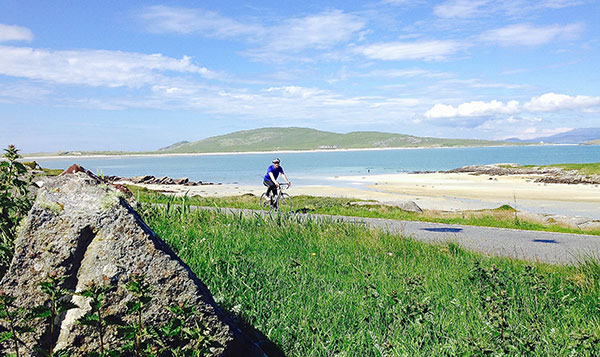
In this part of Scotland the weather is always a gamble. But, on my recent visit, the gods smiled on the Hebrides while London was deluged by a three-day monsoon. The sun warmed our bones, reflected off miles of empty, pristine sandy beaches and bays of shallow turquoise water, while southerly winds pushed us onwards past lochs, peat bogs, moorland and lush, flower-strewn machair towards our end point at Stornoway.
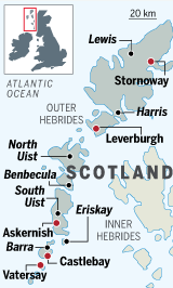
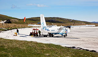
My start was on Barra, towards the southern end of the archipelago, eight miles long and four miles wide. The small propeller plane from Glasgow came in from the southeast and circled low enough to scatter sheep before plopping down on the beach that doubles as the island’s runway. Within half an hour I was pedalling with my guide Paul Easto, heading in a leisurely way along a single-track road towards the small main town of Castlebay and its medieval fortress of Kisimul Castle before veering south for a loop around the neighbouring island of Vatersay. I was accompanying Easto, a director of the tour operator Wilderness Scotland, on his final recce before the trips launched last month; normally they will be run in small groups of up to eight riders.
That Vatersay is now joined by a causeway is partly thanks to a bull called Bernie, who drowned swimming across the sound en route to mate with Vatersay’s cows in 1987. The loss of this prize animal was apparently the last straw for the islanders, and the resulting £3.8m link was finished three years later.
After a pause to paddle in the sea, I pedalled on to the Barra Beach Hotel at Halaman Bay which, in the middle of 1979’s turbulent revolution, sheltered the Shah of Iran’s children. Their former nanny still lives nearby. There can surely be fewer places on the planet more unlike the traffic-clogged streets of Tehran. Cloaked by sea mists and battered by roaring Atlantic gales, this must have seemed the perfect hiding place. For me, though, tranquillity reigned. It was still light past 10pm and warm enough to wear a T-shirt. No one else was on the sweeping stretch of sand. Towards 11pm, I gave up waiting for the sun to hit the water and went to bed.
The next morning Easto and I took the 40-minute ferry to Eriskay, with its single road built in the 1930s and rocky moorland flanked by yet more coves and gorgeous beaches. It was here in 1745 that Bonnie Prince Charlie landed on a small frigate to launch the Jacobite rising. More recently it was where the 12,000-ton steamship the Politician ran aground in 1941, spilling her cargo of more than 250,000 bottles of whisky, which was salvaged by the islanders who then drank their way through much of it. Thirty-six men from Eriskay, including a 14-year-old boy, were sent to court by His Majesty’s excisemen, who came to investigate, and 19 of them were imprisoned in Inverness – something not touched on in Sir Compton Mackenzie’s book Whisky Galore (1947) or the subsequent 1949 Ealing comedy.
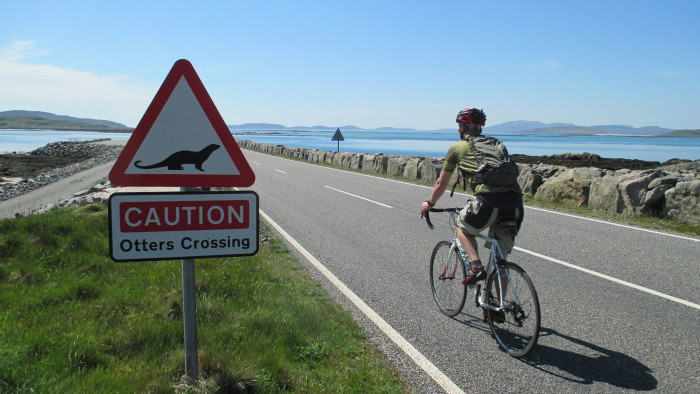
Easto and I pulled into the Am Politician pub for a lunchtime reviver, alone apart from an elderly couple chatting in softly-lilting Gaelic. We then mounted up, pedalling past a sign that warned of “Otters crossing” near a causeway that brought us to South Uist.
The island’s Atlantic coast is generally one long sandy beach and we rode right on to it at Askernish, where you can see the remains of several Bronze Age roundhouses dating from around 1200BC. Then onwards past Loch Bi and on to Benbecula, where the Catholic south of the Outer Hebrides morphs into the Protestant north, and up to North Uist, a patchwork of salmon- and trout-filled lochs that only tenuously seems to be held together by land, before collapsing at the Langass Lodge, snuggled between moors and Loch Langais.
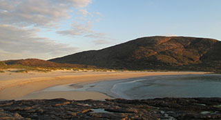
The weather gods smiled less sweetly on us for the remainder of the trip but at least the rain held off and, truth be told, a low, grey, rumbling sky seems to highlight the gold of the sands, the transparent blue of the shallow bays and the green of the hills. Or so it seemed on Harris, reached by a 50-minute ferry that zigzagged its way to Leverburgh, named after Lord Leverhulme, the soap magnate and owner of the whole island up to his death in 1925.
We stopped at the docks for coffee at the parked-up “Butty Bus”, where my Sassenach moment of the week was to ask for what looked like an almond tart only to be told in no-nonsense terms: “That’s an Ecclefechan cake, pal.” If he wasn’t voting Yes to Scottish independence on September 18 before now, I think I swung his vote.
Harris and, to the north, Lewis (one island, two names) seemed grander than their cousins further south: in some parts, roads even had a lane in each direction, a novelty up until now. Even so, settlements remain few and far between, due in no small part to the legacy of the land clearances of the 18th and 19th centuries when arable tenants were forced off their farms to make way for sheep rearing, and subsequently scattered across the Atlantic or to Australia and New Zealand.
Travel details
Will Hide was a guest of Wilderness Scotland (wildernessscotland.com) and Flybe (flybe.com) and the Outer Hebrides Tourism Industry Association (visitouterhebrides.co.uk). Wilderness Scotland’s week-long cycling trips from Barra to Stornoway cost from £1,195 including ferry crossings from the mainland. Flybe flies from Glasgow to Barra, and from Glasgow, Edinburgh and Inverness to Stornoway from £138 return
We coasted round the Golden Road, so-called because of the cost to build it in the 1940s, pausing at the imposingly stark 16th-century St Clement’s Church, built for the chiefs of the Clan MacLeod. From this side of the island, so-called coffin routes led over the mountains to the west coast, where it was easier to bury folk than under the rocks of the east. Certainly for visitors, it’s the utterly glorious beaches of the west, such as at Luskentyre, that grab the limelight. Earlier this year Harris and Lewis was named the world’s fifth best island by contributors to TripAdvisor, something locals say has had an immediate effect, with an increased number of Dutch and German camper vans, in particular, making the long journey from the continent.
Our approach to Stornoway was via the impressively solitary standing stones at Callanish, whose origins remain mysterious but are believed to date from around 2900BC. Thirteen stones stand in a circle with a further 33 monoliths radiating outwards, arranged like a Celtic cross. The Greek explorer Pytheas came across them in 325BC but over time they were partially buried under peat until they were fully revealed again in the mid-19th century.
The last push was across the bleak, boggy landscape of the centre of Lewis, cut in two by the Pentland Road until the big city (Stornoway: population 12,000) came into view.
Some of those celebrating the end of the working week at the Criterion bar on Point Street seemed on the cheerfully wobbly side of oblivion but Easto and I aimed round the corner for the Digby Chick restaurant, which served up the best meal of the trip, and was a fittingly stylish way for us to celebrate the end of our 173 miles. My bottom was slightly numb and my shoulder blades ached but after a few glasses of 10-year-old malt, even those hills seemed a lot flatter.
Photographs: Wilderness Scotland; Alamy; Will Hide
Comments